 Location |
|
How to get to Coalhouse Fort |
|
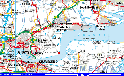
Lat: 51:28:06N (51.4683) Lon: 0:25:36E (0.4267) Explorer 163 Landranger 177 Grid Ref: TQ686771 By Road: From junction 30 on the M25 travel East (towards Southend) along the A13 to the A128 roundabout. Take the third exit along the A1013. Follow the signs for East Tilbury. Approx 3/4 of a mile you will turn RIGHT into BUCKINGHAM HILL ROAD follow the brown tourist signs to Coalhouse Fort and East Tilbury Once in Buckingham Hill Road keep going and you will enter the village of LINFORD, carry on ahead at Mini Roundabout. Over rail crossing at East Tilbury Station passing through East Tilbury then onto East Tilbury Village At the end of the Village you will enter the COALHOUSE FORT car park with the fort located a 75m walk. PLEASE DRIVE CAREFULLY THROUGH OUR VILLAGE SatNav For those who use a Sat Nav we have created POI's file for some of the popular SatNav devices. To use download the POI file from the list below, that corresponds to your SatNav type (zip format) decompress with Winzip or similar, then refer to your SatNav instructions for correct proceedure to install.
TomTom : Garmin : Navman: Magellan -------------------------------------------------------------------------------------- By Rail: East Tilbury Station is on the London, Tilbury and Southend line from Fenchurch Street. East Tilbury station is about two miles from the fort. Exit Station, Turn RIGHT the fort is around a 15 to 20 minute walk -------------------------------------------------------------------------------------- By Bus: There is a bus service during the week (times vary) but none on Sundays. Light refreshments are available in the fort during open days and the nearby Ship Inn public house serves meals. Disabled Access: Whilst every effort has been made to assist the disabled to appreciate the history and architecture of this magnificent building, we regret that, due to its structure, a number of areas within the fort are not fully accessible for wheelchairs. The parkland around the fort has a number of pathways that are suitable for wheelchairs. ----------------------------------------------------- Maps To view a detailed map of how to find Coalhouse fort we suggest visiting Google Maps and entering into the search field Coalhouse Fort, there you will be able to view a very detailed street map, find more information and view a satellite image. You may also find the fort via MULTIMAP link
|